Hurricane Laura is forecast to form later today after having successfully navigated the length of Bermuda and the Caribbean and emerged over the Gulf of Mexico where there is plenty of fuel for Laura to intensify further, although models dispute how strong a hurricane it could become.(Note: We’ve updated this article in parts to reflect the latest information).Yesterday’s double strong tropical storm or hurricane threat fizzled out somewhat, to the relief of insurance and reinsurance interests, as tropical storm Marco weakened before making landfall in Louisiana.
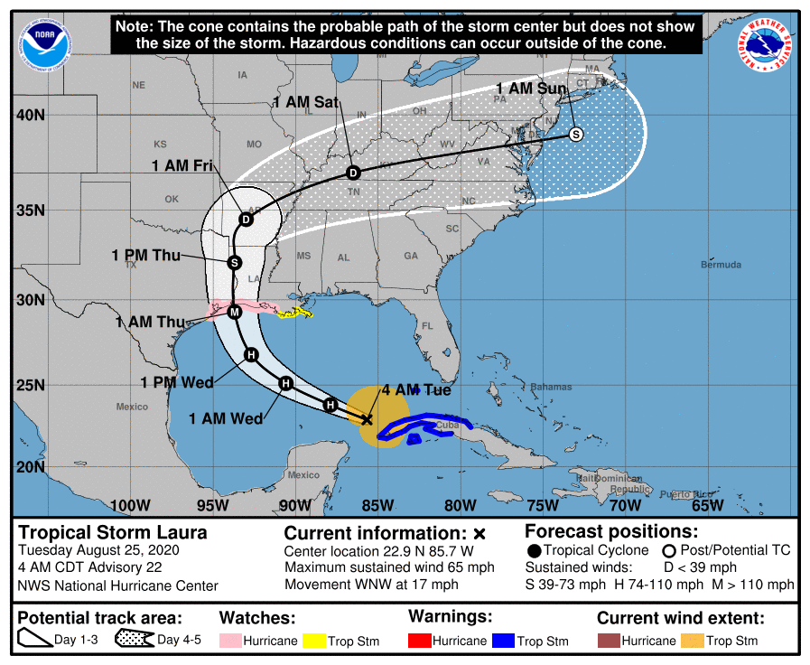
Still a tropical storm for now, Laura has just moved beyond Cuba and once free of land interaction is expected to intensify swiftly into a hurricane.In its latest update, as of 10:00 BST on Tuesday 25th August, NOAA now says that it expects hurricane Laura will reach major hurricane status of Category 3 or higher as it approaches a Gulf Coast landfall.In addition, the track for Laura has shifted slightly further west, as many models had been agreement it would, suggesting more time over the Gulf of Mexico’s warm waters and a greater chance of intensification.
There’s not much in the way of hurricane Laura to hinder its development with wind shear conditions improving and environmental factors becoming more conducive to intensification.Given the very warm Gulf SST’s in Laura’s path, a significant landfalling hurricane cannot be discounted at this stage.NOAA’s latest forecast suggests a Cat 3 or stronger hurricane Laura will make landfall early on Thursday morning right on the Texas / Louisiana border.
Some forecast models still suggest a strong Cat 1 to low Cat 2 landfall around the Louisiana to Texas border area, but some others continue to push for hurricane Laura to spend longer over the warm waters of the Gulf of Mexico and head for land further west into Texas as a stronger storm, potentially a major Cat 3 or stronger hurricane.Greater clarity should emerge later today once hurricane Laura has formed and had some time to organise itself over the Gulf waters.Right now, tropical storm Laura has maximum sustained winds of around 65 mph with higher gusts.
A large storm, Laura has tropical storm force winds extending outward up to 175 miles from the center.The NHC’s forecast cone, seen above, continues to direct the eye of hurricane Laura at Cat 1 or 2 strength into Louisiana, which is a less populated and high-value, in terms of insurance and reinsurance market exposure, region of the Gulf Coast.But some of the forecast models, in particular the ECMWF, has been putting hurricane Laura’s approach further west and recent runs of this model show a Category 3 or 4 major hurricane Laura coming ashore in Texas, just slightly to the east of the Houston area, a far more impactful scenario for insurance and reinsurance interests.
Meteorologists have been tracking south-westward shifts in Laura’s track and are warning that if this continues today the consensus for the hurricane landfall may move well into Texas and as a result the threat to lives will be significantly greater as well.Modelled intensity guidance for tropical storm Laura can be seen below (from TropicalTidbits.com), demonstrating the wide range in model determination from a Cat 4 hurricane Laura to barely a Cat 1: Whatever the scenario, the latest warnings from the NHC forecast a storm surge of as high as 7 to 11 feet and more widely 4 to 6 feet, as well as isolated maximum rainfall totals of 12 inches from hurricane Laura as it approaches landfall.Should hurricane Laura get to intensify more, by spending more time over the Gulf of Mexico with a more westerly track, then there is the potential for those forecasts to be increased, in particular the storm surge which is already at life threatening levels.
So, while Marco proved to be a damp squib, Laura is threatening a much greater impact to lives, livelihoods and property, with the ramifications for insurance, reinsurance and insurance-linked securities (ILS) interests potentially much higher as well.We’ll know more later today once it becomes more evident just how well hurricane Laura will organise over the warm Gulf waters and how much it can intensify.We’ll keep you updated and you can .———————————————————————.
All of our Artemis Live insurance-linked securities (ILS), catastrophe bonds and reinsurance can be accessed online.Our can be subscribed to using the typical podcast services providers, including Apple, Google, Spotify and more.
Publisher: Artemis


