The tropics and Invest 94L, which is anticipated to become tropical storm Imelda in the next day or so, is seen as a potential US landfall threat.Some forecast models suggest a low-category hurricane landfall on the southeast coastline, with the Carolinas seen as one possible outcome.It is early in this storm’s life though and uncertainty remains high.Meanwhile, the remnants of what was once major hurricane Gabrielle is currently bringing strong winds and a soaking to the Azores, and is also expected to bring heavy rains as far as into southern Portugal and Spain in the coming days, as this long-tracked system nears the end of its life.
At the same time, now tropical storm Humberto is moving across the Atlantic and continuing to strengthen, with forecast models suggesting this could become another very large hurricane, potentially at major intensity, but with a track forecast that suggests it will pass between the United States and Bermuda as it recurves (similar to what was seen with hurricane Erin).Track these two storms on our dedicated page.But area of investigation 94L has more potential to become notable to the insurance and reinsurance industry, given its track forecasts at this time.
Significant uncertainty exists in the forecasts still, not least because there is a chance future tropical storm Imelda could interact with Humberto in some way, the two systems being relatively close together in the Atlantic.But, increasingly, forecast models are calling for 94L to become increasingly organised as it moves away from Hispaniola and the Turks and Caicos Islands, through the Bahamas and then heads towards the southeastern US.The National Hurricane Center gives Invest 94L an 80% chance of development into tropical storm Imelda in the next 48 hours.
Both GFS and ECMWF models suggest a hurricane Imelda landfall is possible next week, somewhere on the southeastern US coastline with the Carolinas most favoured at this time.Intensity wise, currently the models only suggest something in the low category range, 1 or 2 it seems.Some of the specialist hurricane models intensify 94L further, while there are also model runs that take the storm nearer to Florida as well.
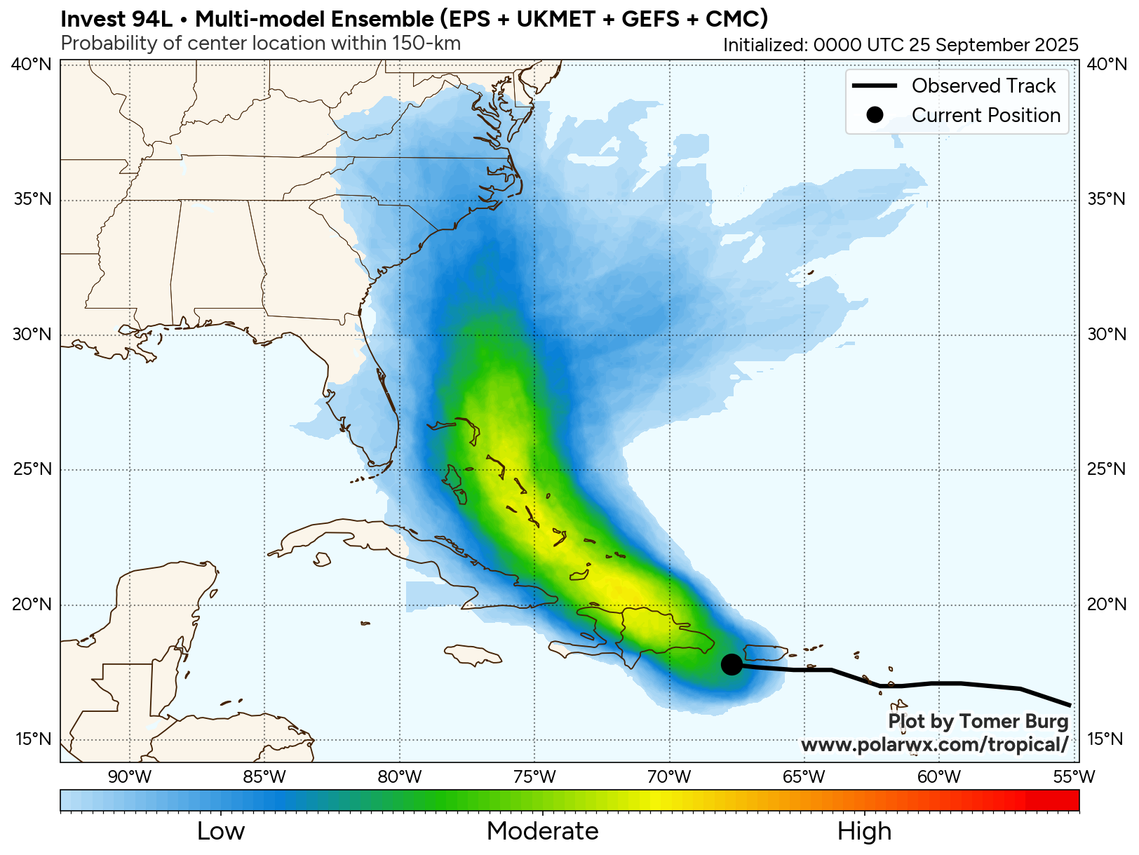
You can see the super-ensemble model graphic from Tomer Burg below: Moderate wind-shear and some dry air entrainment may hinder Imelda’s development over the coming days, while its forward pace is seen as critical to whether it eventually makes landfall (likely in or near to the Carolinas) or gets swept up with Humberto in a Fujiwhara effect that pulls it back out to sea.But, at this time there’s a wide-range of potential outcomes and Imelda has not even been named, so uncertainty is high and as a result the insurance, reinsurance, catastrophe bond and insurance-linked securities (ILS) industry will watch closely as this situation develops over the weekend.Imelda is also expected to be asymmetric in shape which could push rainfall ahead of it and some forecasters suggest that even at low category hurricane strength Imelda’s rains may be worse than its winds should any landfall occur.
Sharing his insights on LinkedIn, BMS Group Senior Meteorologist Andrew Siffert commented on the potential for 94L to become a concern for the insurance industry.Siffert explained yesterday, “The biggest concern for the insurance industry remains the tropical wave labeled 94L, which is currently impacting Puerto Rico and the Dominican Republic with heavy rainfall. This system is expected to become named storm Imelda tomorrow, Saturday, or Sunday. Currently, there are numerous factors to consider, including those that steer and others that aid or inhibit development.
Topography is the initial inhibiting factor for 94L. This will determine where the low will actually develop, specifically in the Turks and Bahamas, but that is where guidance indicates it should occur this weekend.Expect lots of unsettled weather there with a developing system.
Then the question is: where does it go? Lots of spread in the guidance, with it either coming into the southeast coast or getting close enough, then heading out.“Currently, you should focus on using the multi-model ensemble for guidance, rather than relying solely on a single model.The ECMWF ensembles show a weaker named storm tracking into South Carolina, similar to Tropical Storm Chantal this season.
I don’t follow the GFS.Google’s New DeepMind AI model, which has been doing well this season, is mixed with more solutions taking tracks behind Humberto.Currently, the multi-model is indicating a 40% chance of a named storm affecting the Carolinas.
Please note that some of the special hurricane models blow it up into a major hurricane before landfall. Regardless of what happens, it will likely be an early next week situation, whether there is a potential landfall or not—there is still much to unravel here, so stay tuned.” The situation with future tropical storm Imelda will clarify over the coming days, as it becomes more defined and the models get a better handle on its forward speed and direction of travel, as well as whether Humberto will get close enough to change its course.Most forecasters are saying that if it does head towards the US southeast coast to make landfall that is likely late Monday to middle of Tuesday local time, depending on forward speed.
It’s worth noting, that should that happen, most models point to a low category hurricane, which would keep the eventual insurance and reinsurance market loss at more manageable levels and perhaps mean the cat bond and ILS market remained less affected, or even avoiding major impacts from such a storm.But, uncertainty remains high and given Imelda has not even been named yet the market will need to see how the next 24 to 48 hours pan out for this tropical disturbance and a better idea of any potential for impacts and losses should be available by Sunday, seems to be the view of many meteorologists in the industry at this time.Track the on our dedicated page and we’ll update you as new information emerges..
All of our Artemis Live insurance-linked securities (ILS), catastrophe bonds and reinsurance can be accessed online.Our can be subscribed to using the typical podcast services providers, including Apple, Google, Spotify and more.
Publisher: Artemis


