


Jamaica’s $150 million parametric World Bank catastrophe bond has been marked down on secondary pricing sheets and this morning the US National Hurricane Center forecast cone shows a major hurricane Melissa landfall as possible.The latest forecast as of Saturday morning October 25th, sees the NHC’s forecast cone centred on the island nation of Jamaica, with the current forecast indicating a potentially devastating landfall scenario for what is still an intensifying tropical storm Melissa at this time.Melissa is expected to reach hurricane status soon and then intensify rapidly.This article was originally published on October 25th.
Melissa became a hurricane on Saturday evening UK time..It’s important to note that there remains considerable uncertainty and the forecast could change, sparing Jamaica from a major hurricane direct landfall.
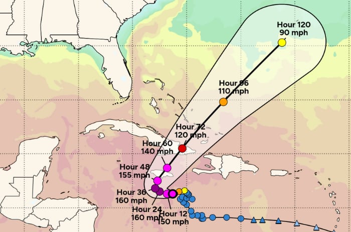
The NHC forecast cone currently points to landfall as occurring on Tuesday 28th, with a slow moving Melissa forecast to enter a phase of rapid intensification as it moves slowly towards Jamaica.The forecast at this time shows hurricane Melissa intensifying rapidly to become a major storm, with wind speeds potentially reaching 155 mph prior to landfall in Jamaica and 145 mph when it gets to the coast, a scenario no one wants to see for the people in its path.You can see Tomer Burg’s graphic of the NHC forecast cone with the forecast advisory wind speeds below (this image should update over time): It means there are a number of days left for the steering currents to hopefully shift Melissa away from this major hurricane landfall outcome.
For the people of Jamaica we certainly hope that the forecasts become more favourable over time.But numerous forecast models continue to show a landfall event in Jamaica at major Category 4 or 5 strength, which could be particularly impactful for the country and a severe danger to lives, livelihoods and property there.The forecasts currently show a scenario that would put Jamaica’s parametric World Bank catastrophe bond at meaningful risk of being triggered, with a number of models showing a deep enough pressure to potentially activate the cat bond’s payout mechanism.
The NHC’s forecast as of Saturday morning suggests a major hurricane Melissa landfall with sustained winds of as high as 155 mph, a scenario that would suggest Melissa’s minimum central pressure could fall to levels low enough to trigger the World Bank facilitated catastrophe bond, should it pass through one of the parametric boxes at a pressure low enough to activate a payout.As we’ve explained previously, it is central pressure and location of a hurricane that matters for the cat bond, with Jamaica and the surrounding sea broken into parametric boxes for the IBRD cat bond’s trigger ().We understand that the lowest payout threshold possible is for a 30% triggering of the cat bond note principal, while a more intense storm can cause a full payout just for entering a single box.
Parametric boxes can also be additive, in that if a storm passes through more than one the payout for each can get added together, under certain circumstances.Given the number of days left before the currently forecast landfall, there remains a good deal of uncertainty and the path Melissa takes as it intensifies and meanders through the Caribbean could be critical in whether or where a direct landfall takes place.But whether it directly passes over Jamaica or not, hurricane Melissa looks set to bring significant impacts to Jamaica, with some days of tropical storm and hurricane wind speeds and well over 20 inches of rainfall deemed likely now, a dangerous scenario even if landfall does not occur.
Given the evident risk to the Jamaica catastrophe bond, we’re told the notes have been marked down in a number of the cat bond market’s secondary pricing sheets, with bids now ranging from as low as 60 cents on the dollar, indicating market uncertainty as a hurricane approaches.However, given the evident threat of a triggering event, if the current forecast scenario plays out, it seems unlikely any live cat trading would be seen unless at more distressed pricing levels.You can .
If the current NHC forecast were to play out we assume Jamaica’s parametric disaster insurance arrangements would also face a high risk of being triggered and these are structured in such a way as to activate and payout before the cat bond, with the cat bond sitting at the highest, more remote layers in the country’s sophisticated disaster risk financing tower.What will become major hurricane Melissa also poses a significant threat to eastern Cuba as well, where a landfall is also currently forecast at major wind speeds.For the people of Jamaica and Cuba we hope the forecast shifts with time over the next few days, to minimise the chances of what could be a particularly devastating and dangerous scenario for these regions.
A faster forward pace could reduce the time available to intensify, or a more westward track as some models were still showing yesterday could take Melissa around Jamaica.But even the GFS model, which has been an outlier in taking hurricane Melissa north earlier and to the east of Jamaica, is now moving closer to the country with each model run.We will likely update this article over the weekend as the situation develops.
Melissa has now become a hurricane with 75 mph sustained winds.The forecast cone has not changed significantly, with a major hurricane landfall still indicated for Jamaica.The NHC stated, “Maximum sustained winds have increased to near 75 mph (120 km/h) with higher gusts.Rapid intensification is forecast to occur over the next couple of days and Melissa is forecast to become a major hurricane by Sunday.” The NHC also said, “A turn to the north and northeast is forecast on Monday and Tuesday.
On the forecast track, the center of Melissa is expected to move near or over Jamaica during the weekend and early next week, and it could be near or over eastern Cuba by the middle of next week.” Melissa has intensified rapidly into a major hurricane with sustained winds put at 120 mph in the last NHC update, but meteorologists say that the satellite presentation already suggests higher winds at this time.The forecast remains for hurricane Melissa to continue intensifying into a Category 4 or 5 storm, then track towards a landfall on Jamaica early in the new week.The dangerous situation for Jamaica has not lessened at this time, with significant impacts from major hurricane Melissa anticipated.
The outlook for the Jamaica catastrophe bond remains uncertain, with scenarios showing pressure levels that could trigger the notes still.However, it will come down to landfall pressure as hurricane Melissa moves into the cat bond’s parametric box structure, to define whether a triggering event occurs and a partial, or full, payout comes due.Hurricane Melissa has continued to intensify and now has 140 mph sustained winds, making it a highly dangerous Category 4 storm.
Minimum central pressure has now dropped to 944mb, putting it well into the low-ranges that could potentially activate the parametric trigger of the catastrophe bond Jamaica benefits from, should the storm move closer to the island at this level of intensity or higher.The latest NHC forecast states that continued rapid intensification is expected through tonight with Melissa expected to become a Category 5 hurricane, followed by fluctuations in intensity.The current NHC forecast advisory suggests a potential peak in sustained winds at around 160 mph as hurricane Melissa approaches Jamaica, but a slight weakening to winds of around 135-140 mph prior to landfall and then to 120 mph winds once the eye moves ashore.
This scenario will certainly pose a threat of triggering to Jamaica’s cat bond protection, which could provide valuable disaster insurance financing to aid in recovery if it is activated.With the cat bond sitting at the top of a tower of layered disaster financing and parametric insurance arrangements, those layers beneath the cat bond would likely activate or be triggered first, such as parametric CCRIF insurance coverage.As we understand it, the parametric trigger for the cat bond requires the “b-deck” track data from the Automated Tropical Cyclone Forecast (ATCF) System to be used for the calculation agent process.
That data can become available relatively quickly after a storm in some cases, but that is the input required to truly understand whether a trigger event has occurred.However, the NHC’s landfall pressure report at the time hurricane Melissa reaches Jamaica should give a reasonable indication whether some kind of payout is likely, or not.Landfall is expected either late Monday night or early Tuesday morning local time, at this stage, so there is still some time to go for the picture to become clearer, or for Melissa to encounter some less favourable conditions that could lessen the expected impact.
At this time the forecasts continue to indicate a particularly devastating storm for Jamaica is the most likely outcome..All of our Artemis Live insurance-linked securities (ILS), catastrophe bonds and reinsurance can be accessed online.
Our can be subscribed to using the typical podcast services providers, including Apple, Google, Spotify and more.
Disclaimer: This story is auto-aggregated by a computer program and has not been created or edited by Health Insurance USA.
Publisher: Artemis
Publisher: Artemis