


Hurricane Eta is forecast to make landfall in Nicaragua, Central America early on Tuesday local time, with significant impacts seen as likely.Further ahead, some of the weather models show hurricane Eta moving back into the Caribbean next week with a chance of the storm becoming a U.S.threat as it refuses to dissipate.
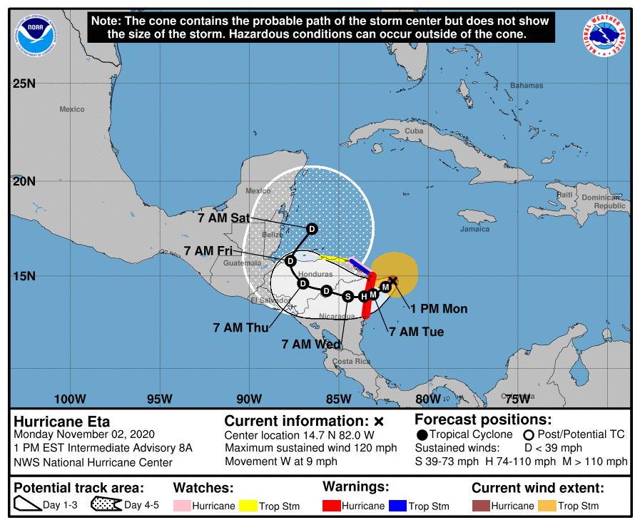
Hurricane Eta is currently moving west towards landfall on the Nicaraguan coastline, with sustained winds of 110 mph and higher gusts.The NHC warns of the potential for additional rapid strengthening before landfall and Eta is expected to become a major hurricane before it strikes Nicaragua tomorrow.Hurricane Eta is forecast to bring a significant storm surge to coastal areas of Nicaragua, with water levels perhaps set to rise 12 to 18 foot above normal, depending on the timing of landfall and the direction of Eta’s winds.
The NHC warns of life threatening impacts from hurricane Eta’s storm surge and if Eta does intensify even further this could be particularly catastrophic for those in the landfall region.Hurricane Eta’s minimum central pressure is 962 mb and expected to fall further, while hurricane force winds extend 25 miles from the center and tropical storm force winds up to 115 miles.Rainfall is also going to be an issue for the Central American region, with hurricane Eta forecast to bring widespread amounts of 10 to 20 inches, but with localised totals of as much as 35 inches potentially seen in Nicaragua and Honduras.
That level of rainfall will bring a severe risk of flooding and landslides.On hurricane Eta’s winds, the NHC warns, “Continued strengthening, possibly rapid, is expected through early Tuesday, and Eta could be a major hurricane when landfall occurs by early Tuesday.Weakening will begin after the system moves inland.” You can see some modelled intensity forecasts for hurricane Eta below, from TropicalTidbits.com: With insurance penetration and insured values much lower in Central America, the potential for hurricane Eta to create a loss for the reinsurance market is much slimmer than for storms threatening the U.S.
But hurricane Eta may not disappear as quickly as would normally be the case with a storm heading west into Central America, as forecast models show Eta spinning north, then back east as a depression and emerging again over the Caribbean at the weekend or early into next week.At that point it seems all bets are off with what Eta will become, as some model runs are showing Eta (or remnants of it) once again re-strengthening into a significant storm in the Caribbean.Further ahead, perhaps tend days to almost a fortnight from now, some models even show a hurricane Eta (or whatever it gets named as) travelling north towards the Florida Panhandle region, or even the west coast of the peninsula.
These scenarios are modelled a long way ahead, but right now it seems that a U.S.threat from hurricane Eta cannot be ruled out at this stage.Which obviously sets up another potential hurricane threat for the reinsurance and ILS market, should that scenario occur.
If hurricane Eta’s remnants manages this feat of surviving mountainous Central America and re-intensifying in the Caribbean, the models suggest it could become a much larger hurricane.How intense that would be remains to be seen, but the central Caribbean sea surface temperatures are plenty warm enough to power a significant hurricane at this time of year.Even further afield, some forecast models show this rejuvenated Eta moving across Florida and then up the U.S.
east coast, with an extra tropical transition occurring that helps it morph into a massive northeast coast extra-tropical storm.Again, these are modelled scenarios, not forecasts at this stage, so right now outliers.But, if the stars were to align and these model forecasts verify, it looks like the insurance, reinsurance and ILS industry may end up watching and potentially worrying about hurricane Eta, or at least its legacy, for some days to come.
The NHC’s forecasters highlighted the uncertainty, saying, “Although Eta’s low-level center may not survive after being inland over Central America for so long, most of the global models depict a cyclone over the northwestern Caribbean Sea later this week and into the weekend which appears to develop from at least a part of Eta’s remnants, and the new NHC track forecast shows the system emerging over the northwest Caribbean Sea after 96 h.However, the uncertainty in the long-range portion of the forecast remains quite high.” The 2020 Atlantic hurricane season keeps on giving, with this now 28 named tropical storms (a tie for the record ever recorded), 12 hurricanes and with the potential for Eta to become the seasons fifth major hurricane as well.———————————————————————.All of our Artemis Live insurance-linked securities (ILS), catastrophe bonds and reinsurance can be accessed online.
Our can be subscribed to using the typical podcast services providers, including Apple, Google, Spotify and more.
Disclaimer: This story is auto-aggregated by a computer program and has not been created or edited by Health Insurance USA.
Publisher: Artemis
Publisher: Artemis