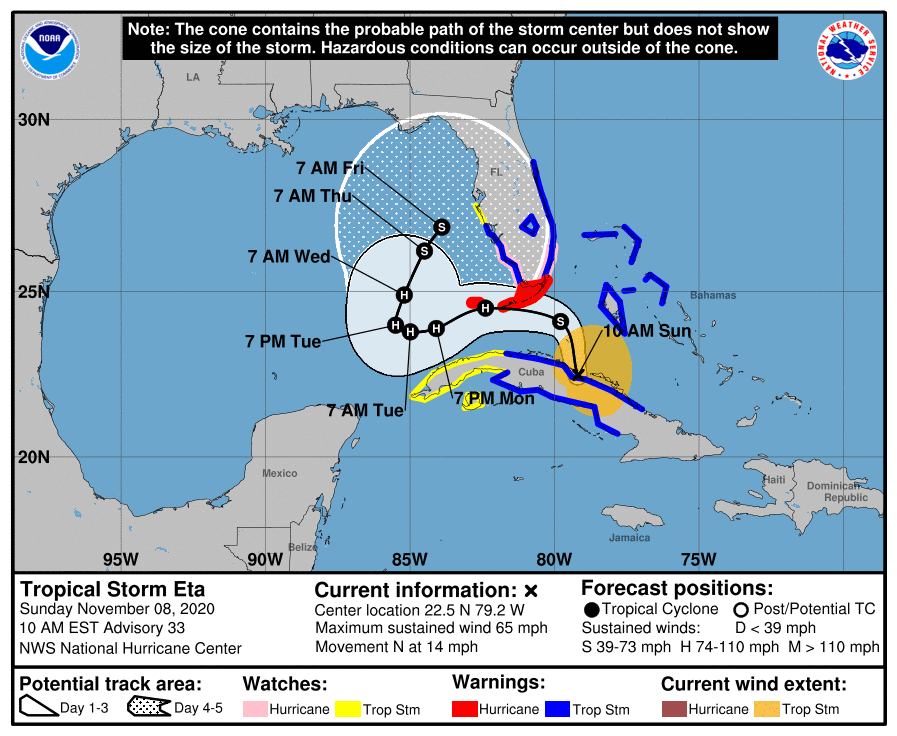
The state of Florida is now under a hurricane watch as tropical storm Eta approaches and is expected to strengthen once it has crossed Cuba and makes a path for a forecast landfall in the Florida Keys, with the potential for a second impact for the state later this coming week as well.Eta was at one stage the strongest hurricane of the 2020 Atlantic season, but then weakened considerably before taking a meandering path back into the Caribbean., meaning that this has become another weekend of watching the tropics for the insurance, reinsurance and insurance-linked securities (ILS) industry.
Tropical storm Eta intensified as it crossed the Caribbean towards Cuba, as had been forecast, reaching 65 mph sustained winds before making landfall on the island.On its path, tropical storm Eta also soaked the Cayman Islands, with reports of downed trees from strong winds, some coastal damage, as well as localised flooding from Eta’s heavy rains.Cuba is facing strong tropical storm force winds with the potential for gusts of close to hurricane strength with Eta, as well as up to 4 feet of storm surge and rainfall totals as high as 25 inches from the tropical storm.
After crossing Cuba, tropical storm Eta will emerge over the straits of Florida, where the warm waters are expected to help Eta re-strengthen and as a result Florida has a hurricane watch in place for its coast from Deerfield Beach to Bonita Beach and for the Florida Keys from Ocean Reef to the Dry Tortugas, including Florida Bay.Tropical storm Eta currently has 60 mph sustained winds and given it is moving at a reasonably fast pace of 12 mph is unlikely to weaken too much as it crosses Cuba.The NHC’s latest outlook for Eta is below: On the forecast track, the center of Eta will continue to move across east-central Cuba during the next few hours and then move over the Florida Straits later this morning.
Eta is forecast to pass near or over the Florida Keys tonight and early Monday, and be over the southeastern Gulf of Mexico late Monday and Tuesday.Maximum sustained winds have decreased to near 60 mph (95 km/h) with higher gusts.Little change in strength is expected during the next few hours as Eta moves across Cuba.
Re-strengthening is forecast after the storm moves over the Atlantic Ocean, and Eta is forecast to be near hurricane strength when it moves near or over the Florida Keys.Currently the NHC is predicting storm surges of 2 to 4 feet for areas of Florida within the hurricane watch, while portions of the central and southern Florida peninsula, including the Keys could see 6 to 12 inches of rainfall from tropical storm or hurricane Eta, with isolated maximum totals of 18 inches possible.The level of threat posed to insurance, reinsurance and insurance-linked securities (ILS) markets by Eta now depends on how much it can intensify over the straits of Florida as it approaches the keys.
If Eta can regain hurricane status then the surge heights would be expected to rise and wind damage become a possibility.However, Eta is unlikely to become a particularly significant hurricane, given the limited time it has crossing the straits before reaching the Florida peninsula, which could save the insurance and reinsurance market from further heavy losses, although still having the potential to be an impactful event for some carriers that have already experienced multiple hurricane losses this year.There is a chance of a second threat for Florida though, as Eta’s forecast path suggests the storm will veer west into the Gulf of Mexico, where there may be a chance for more intensification, before the storm or hurricane veers back towards the east and depending on steering currents could make a second landfall further north up the Florida Gulf Coast or even into the Panhandle.
Right now, this scenario remains very uncertain and Eta could meander in the Gulf for a time.But that does raise the prospects of a strengthening hurricane over the Gulf, although wind shear may be elevated which could hinder Eta’s further intensification.Right now, the southern Florida impacts seem assured, while the potential for a second impact on Florida or somewhere further north in the Gulf is much less certain.
Forecast models show the chances of Eta regaining hurricane strength here, but we really need to wait a few hours until it passes Cuba to better understand the storms chances of becoming hurricane Eta again.The modelled forecast intensity graphic from TropicalTidbits.com is worth keeping an eye on: So it remains very uncertain how impactful, or not, Eta’s resurgence and effects in Florida could be for the insurance and reinsurance market, let alone for ILS positions.The rainfall and flooding threat persists, with Florida expected to see some flooding and possible coastal impacts from surge.
Eta’s ability to regain hurricane status on its journey north towards Florida is the wild-card, as should it manage this then the insurance and reinsurance market impacts will undoubtedly be higher, as wind and storm surge remain the key drivers of damage with most tropical storm systems.Storms have been seen to intensify rapidly as they cross the Florida straits before, also while over the Keys, so Eta is worth keeping an eye on through the rest of Sunday and into Monday———————————————————————.All of our Artemis Live insurance-linked securities (ILS), catastrophe bonds and reinsurance can be accessed online.
Our can be subscribed to using the typical podcast services providers, including Apple, Google, Spotify and more.
Publisher: Artemis


