


Tropical storm Henri continues to track west and with a turn to the north over the warm Gulf Stream waters anticipated, hurricane Henri is forecast to form at the weekend and head towards the US northeast states of Massachusetts, Rhode Island, Conneticut and New York.Hurricane Henri’s forecast cone and future has all of those northeast US states in it, as well as suggesting potential impacts for New Hampshire and Maine as well.There is significant uncertainty in tropical storm Henri’s future forecast strength and exact path though, which of course make it a storm that insurance, reinsurance and insurance-linked securities (ILS) market interests will watch closely.
The turn to the north is certain, but how far west Henri will track and how close to the coastline it will be, how strong or intense it can become as a hurricane over the Gulf Stream, and how much it weakens as it moves over cooler waters before nearing land, are all very uncertain still.Some forecasters and forecast models suggest a chance that Henri is still at hurricane strength when it nears Massachusetts, potentially even barrelling into Long Island if it tracks a little more westward.A ridge is expected to steer Henri east eventually, but some meteorologists have pointed out that this could be quite weak and if Henri can intensify more than the current forecast anticipates, which there is a chance of, then steering forces could be far weaker.
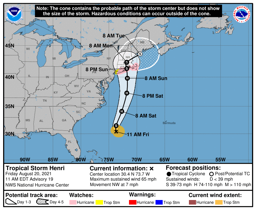
Others stick with the current NHC forecast, that has Henri reaching category 1 or 2 hurricane strength over the Gulf Stream, but then weakening back to a tropical storm as it nears the coast around Massachusetts.You can see the latest forecast cone from the NHC below.The NHC has now raised hurricane and storm surge watches for the US northeast and the latest forecast shows a potential hurricane strength landfall somewhere along the Long Island, Rhode Island, Massachusetts coastline on Sunday.
Any further move west in the track could bring increasingly vulnerable barrier coastal regions under watch as well, with Connecticut and New York not far to the west of the forecast track as well.Strengthening is now the key factor in defining how much of a threat Henri could become as a hurricane, but it’s likely we won’t know until Sunday morning just how impactful it could be for the region.Right now tropical storm Henri has roughly 65 mph sustained winds with higher gusts and is a growing storm.
Once it moves over the Gulf Stream intensification is expected, perhaps quite quickly, while meteorologists are also discussing the potential for Henri to grow in size and also pick up significant moisture, becoming a major rain threat to the US east coast.While Henri will move quite quickly north and so come closest to the US northeast states on Sunday, it is expected to have time to become a threat to property along the way, even if it is only a tropical storm at landfall.Forecasters are discussing the chances of a combined storm surge and torrential rains to cause some issues, while those believing a stronger scenario is likely, are warning of hurricane force winds for the coast and more water related impacts.
The forecast is subject to significant change over the next 24 hours, depending on how strong Henri can become over the particularly warm Gulf Stream waters.You can see GSF model enemble runs below from Tropical Tidbits: Also from Tropical Tidbits, you can see modelled intensity guidance below: Even at tropical storm strength, Henri could be a relatively significant threat to low-lying coastal areas, causing insured property losses as it nears the coast, or makes direct landfall.But some of the more intense and further west landfall scenarios imply a more meaningful insurance and reinsurance market impact.
There is of course also a chance that Henri curves east earlier and misses land, in which case rainfall would be the worst threat for these northeast US states.We won’t know how threatening storm Henri really is until the weekend, once its firmly over the Gulf Stream and has become the forecast hurricane.At that stage there should be more certainty in the eventual path.
Insurance, reinsurance and ILS market interests can keep track of this activity over on our page and we’ll update you should a more significant threat develop.Meanwhile, tropical storm Grace continues to head for its second landfall in Mexico as a hurricane.Intensification is expected, but with less than 24 hours over water this is not expected to be extreme.
As a result, .———————————————————————.All of our Artemis Live insurance-linked securities (ILS), catastrophe bonds and reinsurance can be accessed online.Our can be subscribed to using the typical podcast services providers, including Apple, Google, Spotify and more.
Disclaimer: This story is auto-aggregated by a computer program and has not been created or edited by Health Insurance USA.
Publisher: Artemis
Publisher: Artemis