


A hurricane watch has been issued for parts of the west coast of Florida as tropical storm Elsa moves clear of Cuba and into the Florida Straits.Tropical storm Elsa will now spend some time over warm waters of the Gulf of Mexico, off to the south west of the Florida peninsula, before moving up the coast and eventually making landfall further north.Tropical storm Elsa will battle with relatively strong wind shear which has been impacting its ability to intensify.
Some forecasters continue to believe Elsa could regain hurricane strength before landfall, although the consensus seems to be for a relatively strong tropical storm to come ashore north of Tampa Bay still.However, the NHC warns that, “Slow strengthening is forecast through tonight, and Elsa could be near hurricane strength before it makes landfall in Florida.” But intensification or not, tropical storm Elsa does threaten parts of the Florida peninsula with strong storm force winds and hurricane force gusts, hence the hurricane watch.While storm surge and heavy rainfall are the other main threats that could cause property damage.
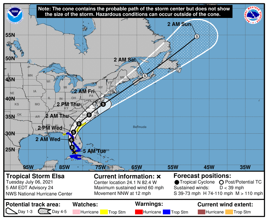
As a result, Elsa is still considered a tropical storm to watch for the insurance, reinsurance and ILS market, as it is expected to bring some damaging impacts.Tropical storm Elsa currently has 60 mph sustained winds with higher gusts.Tropical storm force winds extend outwards 70 miles or more, meaning much of Florida’s keys and west coast could experience storm force winds.
The NHC said that west central Florida and the Big Bend could experience hurricane force wind conditions Tuesday night and into early Wednesday.A Hurricane Watch has been issued for the west-central and Big Bend coast of Florida from Egmont Key to the Steinhatchee River, while a Tropical Storm Watch has been issued for the Georgia coast and portions of the South Carolina coast from the Mouth of St.Marys River to South Santee River, South Carolina.
A Storm Surge Warning is now in effect for the West coast of Florida from Bonita Beach to the Aucilla River, including Tampa Bay and a Storm Surge Watch is in effect for West of the Aucilla River to the Ochlockonee River, Florida.The storm surge could be from 3 to 5 feet from Englewood, FL to Aucilla River including Tampa Bay, while 1 to 4 feet of storm surge is expected more widely along the Florida west coast.Up to 15 inches of rainfall has been experienced in parts of Cuba and while Florida should experience less, there is still a chance of 5 to 8 inches across parts of Florida, Georgia and into the Carolinas.
In addition, forecasts warn of the chance of a few tornadoes as well, along the path storm Elsa takes.Given the current forecast, unless the storm undergoes more rapid intensification than expected, Elsa is unlikely to cause a particularly significant insurance and reinsurance market loss as a strong tropical storm or weak hurricane.But it will cause insured damage and some industry impact, it seems, with the storms footprint potentially quite wide-reaching as weell.
You can see the latest intensity guidance below, from Tropical Tidbits, which reflects a chance of some strengthening through the next day: Also below, you can see a couple of additional forecast models from Tropical Tidbits.Insurance, reinsurance and ILS market interests can keep track of it over on our page and we’ll update you should a more significant threat develop.———————————————————————.All of our Artemis Live insurance-linked securities (ILS), catastrophe bonds and reinsurance can be accessed online.
Our can be subscribed to using the typical podcast services providers, including Apple, Google, Spotify and more.
Disclaimer: This story is auto-aggregated by a computer program and has not been created or edited by Health Insurance USA.
Publisher: Artemis
Publisher: Artemis